Research
Grampian forest habitat network
Research Status:completed
We use some essential cookies to make this website work.
We’d like to set additional cookies to understand how you use forestresearch.gov.uk, remember your settings and improve our services.
We also use cookies set by other sites to help us deliver content from their services.
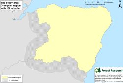
The Grampian forest habitat network study area is defined by the Forestry Commission Conservancy boundary (yellow area on map below), with an external 15 km buffer applied (hatched area on map below). This comprises approximately 1.2 million ha, of which Grampian Region covers 880 115 ha:
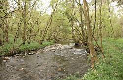
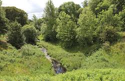
Grampian Region is comprised of a mosaic of land cover types, within a varying topography, from the farmland of the Buchan Plains to the wooded slopes of the Cairngorm mountains. Riparian and wet woodlands are an important component of the wooded landscape and the former are especially important, in terms of connectivity, as they often form corridors linking other areas of woodland.
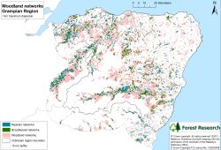
Habitat network analyses for the region focused on an open ground habitat, heathland and five woodland types:
The study also attempted to identify riparian and wet (Carr) woodlands by incorporating a number of methodologies, which were given a hierarchy of confidence:
Forest Habitat Networks Scotland – Grampian Report (PDF-4471K)
Maps showing the potential extent of functional networks for riparian woodlands were examined by 'nesting' these networks within broadleaved networks and woodland generalist networks:
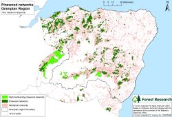
This procedure also enabled wet (Carr) woodland networks, and pinewood networks (map below) to be examined to support regional strategic plans for Grampian:
The networks can also be used at a local scale to determine and prioritise opportunities to reduce habitat fragmentation:
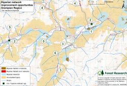
In the above example, the numbers refer to the opportunities listed below:
Cookies are files saved on your phone, tablet or computer when you visit a website.
We use cookies to store information about how you use the dwi.gov.uk website, such as the pages you visit.
Find out more about cookies on forestresearch.gov.uk
We use 3 types of cookie. You can choose which cookies you're happy for us to use.
These essential cookies do things like remember your progress through a form. They always need to be on.
We use Google Analytics to measure how you use the website so we can improve it based on user needs. Google Analytics sets cookies that store anonymised information about: how you got to the site the pages you visit on forestresearch.gov.uk and how long you spend on each page what you click on while you're visiting the site
Some forestresearch.gov.uk pages may contain content from other sites, like YouTube or Flickr, which may set their own cookies. These sites are sometimes called ‘third party’ services. This tells us how many people are seeing the content and whether it’s useful.