Research
Projected changes in warmth and droughtiness of Scotland’s climate
Research Status:current
We use some essential cookies to make this website work.
We’d like to set additional cookies to understand how you use forestresearch.gov.uk, remember your settings and improve our services.
We also use cookies set by other sites to help us deliver content from their services.
Climate scenarios published by UKCIP (2002) have been used to calculate climatic indices of climatic warmth and wetness for the future 30-year climatic periods centred on the years 2050 and 2080, for the low and high emissions scenarios.
The maps below show changes for the low and high UKCIP02 emissions scenarios. These maps represent the upper and lower range of UKCIP02 climate projections for Scotland’s climate.
A convenient measure of warmth representing the potential for plant growth, is given by an index called accumulated temperature (AT). AT is the number of day.degrees over 50C for the growing season (February to October inclusive).
The AT maps below show that by 2080 AT might increase by up to 30% in parts of Scotland in a high emissions scenario, and by 15-20% for a low emissions scenario. In 2080 if the high emission scenario projections occur, Caithness may have a warmer growing season, perhaps similar to East Lothian in the baseline climate.
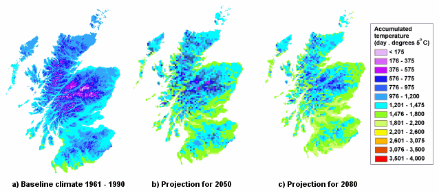
Low emissions scenario projections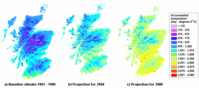
High emissions scenario projections
This index is a moisture deficit (MD), which compares the accumulated excess of monthly evaporation over monthly rainfall for the summer months. The annual maximum accumulated excess (the annual maximum MD) is averaged over the 30-year climate period, to provide a climatic average of the rainfall excess or droughtiness of the climate during the summer months.
The MD maps below show that changes in the regional and seasonal distribution of rainfall suggest the onset of bigger moisture deficits in eastern Scotland. Mean maximum MDs may increase from about 140mm in eastern Scotland to over 200 mm in a high emissions scenario.
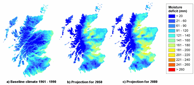
Low emissions scenario projections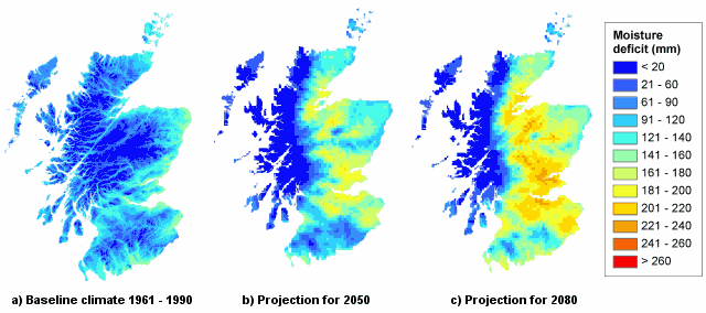
High emissions scenario projections
Cookies are files saved on your phone, tablet or computer when you visit a website.
We use cookies to store information about how you use the dwi.gov.uk website, such as the pages you visit.
Find out more about cookies on forestresearch.gov.uk
We use 3 types of cookie. You can choose which cookies you're happy for us to use.
These essential cookies do things like remember your progress through a form. They always need to be on.
We use Google Analytics to measure how you use the website so we can improve it based on user needs. Google Analytics sets cookies that store anonymised information about: how you got to the site the pages you visit on forestresearch.gov.uk and how long you spend on each page what you click on while you're visiting the site
Some forestresearch.gov.uk pages may contain content from other sites, like YouTube or Flickr, which may set their own cookies. These sites are sometimes called ‘third party’ services. This tells us how many people are seeing the content and whether it’s useful.