Research
Forest habitat network in Scotland
Research Status:completed
We use some essential cookies to make this website work.
We’d like to set additional cookies to understand how you use forestresearch.gov.uk, remember your settings and improve our services.
We also use cookies set by other sites to help us deliver content from their services.
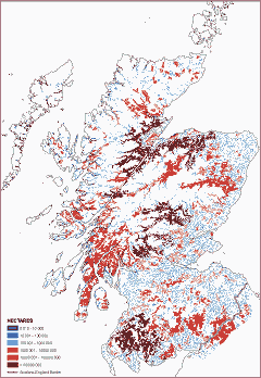
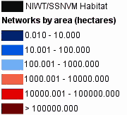
A national map showing forest habitat networks (classified by network size) for moderately mobile (1km dispersal) woodland generalists
The Scottish Forestry Strategy outlined a major aspiration to develop forest habitat networks (FHNs) through the restoration and improvement of existing woodland and the incorporation of targeted new planting. It is expected that in the longer term such measures will reverse the effects of fragmentation on woodland biodiversity.
The Habitat Network Tool from BEETLE (Biological and Environmental Evaluation Tools for Landscape Ecology) uses a focal species approach to assess the functional connectivity of habitat for specific and generic focal species.
The Scotland FHN project expanded on the Scottish Borders and West Lothian pilot studies to indicate the presence and spatial extent of FHNs at the national and regional scale. The outputs have assisted in targeting grants and incentives for woodland expansion.
The project developed a plan to support the strategic development and integration of FHNs and open habitat networks in Scotland.
The project produced scenario maps, to help the Forestry Commission Scotland and Scottish Natural Heritage advise on the expansion and restoration of habitats to protect, and enhance, functional connectivity for woodland and open ground species.
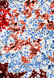
Map (left) shows the extent of habitat networks for mobile woodland generalists in the fragmented woodlands of North Aberdeenshire, Banff and Buchan.
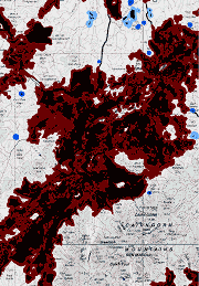
Compare the Buchan map with the size and extent of the functionally connected forest habitat network for mobile woodland generalists in the Spey Valley (below).
National map of habitat networks for woodland and open ground generalists and specialists – April 2005
Regional maps for:
National final report (PDF-4665K) – February 2008
The research is funded by:
Forestry Commission (GB)
Forestry Commission (Scotland)
Scottish Natural Heritage

Head of Land Use & Ecosystem Services
Cookies are files saved on your phone, tablet or computer when you visit a website.
We use cookies to store information about how you use the dwi.gov.uk website, such as the pages you visit.
Find out more about cookies on forestresearch.gov.uk
We use 3 types of cookie. You can choose which cookies you're happy for us to use.
These essential cookies do things like remember your progress through a form. They always need to be on.
We use Google Analytics to measure how you use the website so we can improve it based on user needs. Google Analytics sets cookies that store anonymised information about: how you got to the site the pages you visit on forestresearch.gov.uk and how long you spend on each page what you click on while you're visiting the site
Some forestresearch.gov.uk pages may contain content from other sites, like YouTube or Flickr, which may set their own cookies. These sites are sometimes called ‘third party’ services. This tells us how many people are seeing the content and whether it’s useful.